
StoreyG2 is a small art organisation based in Lancaster in North West England. In the past few years they have carried out two projects exploring landownership.
In the UK about 70% of the land is owned by 0.7% of the population. Unequal ownership of land provides social and economic power, but is little discussed, and information on land ownership is hard to obtain. The UK is unusual in that it does not have an easily accessible cadastral (land ownership) map. In the widespread discussions of landscape, environment, and sense of place, land ownership is rarely mentioned, even though the use and appearance of land is primarily controlled by its owners.
Their first project was “Landed (Freeman’s Wood)”, which focused on a contested plot of land on the edge of Lancaster.
Their second project, “Landed (Cadastral Maps)”, commissioned artists’ maps showing changes in land ownership over historical time. This pilot was a first step, to investigate what information is available. It received funding from Arts Council England and the Landscape Research Group.
For the sample plot, they selected a rural east-west slice of North Lancashire, from the coast to the moors, between OS Northing lines 52 to 55. It’s about 14,000 acres, roughly 12 miles from west to east and 1¾ miles north-south.
StoreyG2 commissioned two artists to work on the project – Layla Curtis and Rebecca Chesney.
Together they searched various archives for historical information, focussing on documents which included maps. The earliest found was an estate map of 1670. Estate auction sale documents were very useful, as they include maps of the plots. They also looked at the 1910 land valuation survey, which has maps, together with record books listing owners.
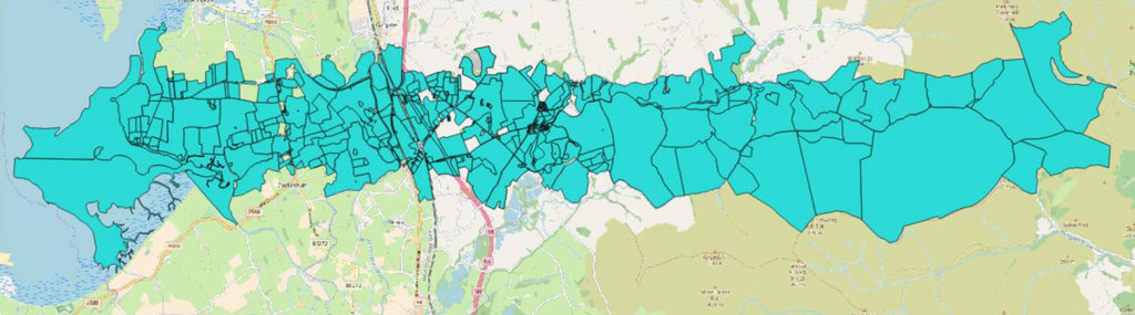
For contemporary landownership they used the Land Registry. Information from its website enabled them to produce a map of the more than 750 registered plots in the sample area, as shown below. Unable to request Land Registry information on all these, due to time and money, they initially narrowed down to 200 plots. After submitting a map to the Land Registry requesting a digital map showing ownership of each of these plots, communication was difficult and time-consuming, so detailed information was obtained on only 50 plots, distributed across the area.

The third source of information was driving, cycling and walking. John Angus of StoreyG2 walked most of the public footpaths in the area, as a great way to understand the landscape.
From these various sources they pieced together an outline history of landownership in the patch. It can be summarised by reference to the significant buildings, which, as might be expected, have been occupied by the major landowners.
Going from west to east, situated on the coast, and the oldest building, is the remnant of Cockersand Abbey. After the dissolution of the monasteries, their landholdings were purchased by Hugh Dalton of Thurnham Hall, which dates back to the 14th century. The Dalton family owned the estate until the 1970s.
William Preston, a Liverpool merchant wanting a country house, bought land and built Ellel Grange in 1858. The 1910 survey shows that the family acquired a lot more land. They too continued in occupation until the1970s.
Wyreside Hall, built in the 18th century by John Fenton Cawthorne, who had inherited a lot of land in our area from his mother’s family. He had 6000 acres when he died in 1831.
The purchaser was Robert Garnett, from Manchester, who had made his fortune in cotton and the railways. The Garnett family extended their estate to 12,000 acres by 1879, and lived in the house until 1936.
They sold some land in the 1880s to the 4th Earl of Sefton, who built Abbeystead House. This was initially intended as a shooting lodge, based in the grouse moors, but became the family home. The Seftons lived there until 1980 after the 7th Earl died, when they had about 20,000 acres. The house and estate was then bought by the Duke of Westminster.
Another significant landowner, but not based in a building, is the Duchy of Lancaster. It seems that the Duchy bought some of the Garnett’s land.
This pilot enabled StoreyG2 to produce an outline of ownership over the past few centuries. It also demonstrated that there is a wealth of information available on the history of landownership in the sample area, indeed the task of collecting it is much larger than anticipated.
StoreyG2 now hopes to obtain funds to build on this pilot and gather more details, possibly using the 1910 land valuation survey as a comprehensive baseline. Our aim is to create a demonstration example of landownership history in the UK, with layered artists’ cadastral maps showing change over time.
More information, photos, research and project report
Applicant: John Angus, StoreyG2
LRG project visit, as part of the Borders & Boundaries event in May 2019
Click for more details, including a podcast with Rebecca Chesney introducing the project.